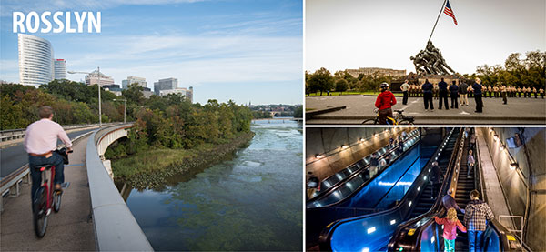
|
Getting Around Rosslyn
The Rosslyn Metro station, on Metrorail's Orange and Blue Lines, is an important bus and rail hub. Rosslyn is served by several Metrobus routes and the Georgetown Metro Connection bus service. Bicyclists can get in and out of Rosslyn via the Custis (I-66) and Mt. Vernon trails, and use on-street trails and bike lanes within the neighborhood. Scroll down or choose a link below for more information about getting around Rosslyn.
ART-Arlington Transit | Metrobus | Georgetown Metro Connection | Bicycling | Walking | Car Sharing | Metrorail | Slug Line | Taxis | Maps | Metro's Trip Planner (door-to-door directions) | Transit Fares & Information
ART-Arlington Transit
ART is Arlington's local bus service. For additional bus service, see Metrobus, below.
Metrobus
Regional bus service for the Washington, D.C. metropolitan area. For additional bus service, see ART, Arlington Transit, above, and Georgetown Metro Connection, below.
- Metrobus routes serving Rosslyn
Georgetown Metro Connection Bus Service
Express service between Georgetown and Foggy Bottom-GWU, Rosslyn and Dupont Circle Metro stations.
Bicycling
- Bike Access Wilson and Clarendon Blvds. have bike lanes west of North Oak St. providing access to Court House. North Scott St. and Key Blvd. have bike lanes providing a connection to the Custis Trail. The Custis Trail, Mount Vernon Trail and Key Bridge can be accessed via North Lynn St. and Fort Myer Dr. The Arlington Blvd. Trail, Iwo Jima Memorial and the Route 110 trail are also accessed via North Lynn St. and Fort Myer Dr.
- Bike Parking Bike parking is available at the Rosslyn Metro Station and at on-street locations throughout Rosslyn.
- Bike Maps
- Bicycling general information
Walking
- Custis and Mount Vernon Trails See Bike Access above.
- Walking Destinations Georgetown via Key Bridge Walkway, Iwo Jima Memorial and Theodore Roosevelt Island.
- To come Key Bridge and Lynn St. Esplanade. Enhanced, safer walkway linking Key Bridge and central Rosslyn.
- Arlington Bike & Walk Options Map Bike lanes, shared use trails, and more. (PDF, 1.1 MB)
- Arlington and Walkability
- WALKArlington
- WALKArlington Map and Guide for Rosslyn Conveniently-sized booklet that includes memorials, public art, architecture, history, parks and plazas, things to do, transportation and links to useful information.
Car Sharing
Zipcar has a number of cars in Rosslyn. For locations and more information, visit the Zipcar web site.
Maps
- Rosslyn interactive map
- Rosslyn Metro neighborhood map (StationMasters)
- Rosslyn Metro bus bay diagram (PDF)
- Arlington Transit Options map Metrobus, Metrorail, ART, and carsharing services on one convenient Arlington map. (PDF, 1.2 megabytes)
- Arlington Bike & Walk Options Map Bike lanes, shared use trails, and more. (PDF, 1.1 MB)
- Other Arlington bicycle maps
- Metrobus schedules and maps
- Metrorail system map
- Arlington County interactive mapping service
- WALKArlington Map and Guide for Rosslyn Conveniently-sized booklet that includes memorials, public art, architecture, history, parks and plazas, things to do, transportation and links to useful information.
Metrorail
Regional rail service for the Washington, D.C. metropolitan area. About the Metro system.
Slug Lines
- Between North Moore Street and North Fort Myer Drive on the Lee Highway service road (approximately 1995 North Moore Street). Exit the Metro station (west entrance) and turn left (north). McDonalds should be on your right as you walk up N. Moore Street and across 19th Street. Signs have been erected to help locate the line. To Woodbridge and Stafford.
- North Kent Street for Springfield/Burke slugs. Turn onto North Kent Street and about 100 feet on the right at the speed-limit sign.
- More information about slug lines
Taxis
Metro's Trip Planner
Use Metro's Trip Planner to find out exactly how to get where you want to go in the Washington, D.C. area, using Metro bus and rail and local bus systems. The Trip Planner asks you where you're starting and when and where you want to go. Then it finds the best way for you to get there using the Metro system and local bus systems.
Transit Fares & Information
|
|